

Shoreline Stabilization and Enhancement Plan for the Beach Road Pathway, Saipan, CNMI
Pacific Coastal Research and Planning | Horsley Witten Group, Inc. | Shoreline Conservation Initiative

Project Update:
The project team and Advisory Committee reviewed 30-percent design plans in August, enabling the advancement of site plans and packaging of initial permitting materials. The team aims to have final engineering plans for the site by December 2024, along with a draft permitting package.
Project Background
The Beach Road Pathway and adjacent shoreline connecting the business districts of Garapan and Susupe on Saipan has long been an area of concern for resource managers, recreational stakeholders, and the network of CNMI agencies involved in building more resilient infrastructure. Recent studies of shoreline change and vulnerability in the project area have highlighted this corridor as one of moderate to high concern for resource managers due to a consistently narrow shoreline buffer, close proximity of high value community assets and adjacent infrastructure, and documented exposure to periodic extreme weather events, wave run-up, and sea level changes. This combination of factors also translated into the CNMI’s highest concentration of “resilience hubs” and priority restoration sites, as delineated by the 2020 NFWF Coastal Resilience Assessment for the Territory.
There couldn’t be a better canvas to design nature-based solutions for coastal resiliency in the Northern Mariana Islands, so that’s exactly what we’re doing!

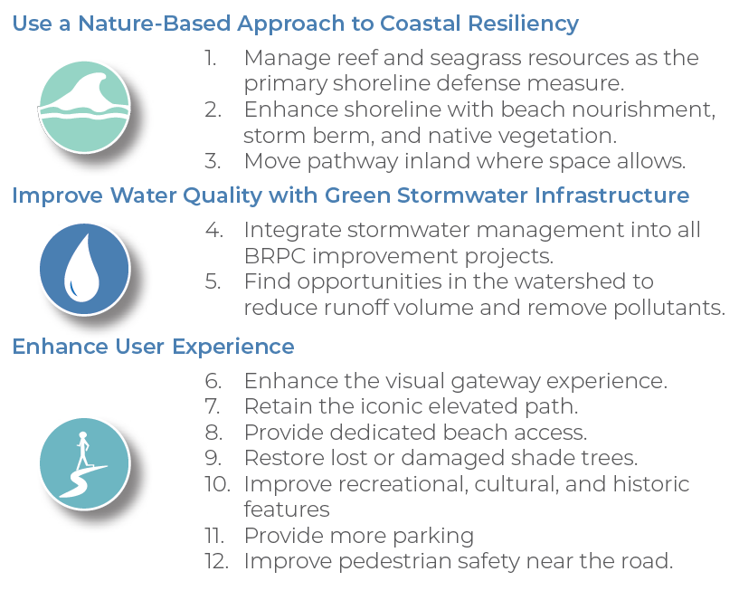
A Beach Road Pathway Corridor (BRPC) Master Plan was developed as a means of fostering both natural and community capacity to cope with disturbances in the BRPC over the next 25-50 years— recognizing that more significant adaptation to our changing climate will be necessary long-term. The planning process included consistent stakeholder collaboration, comprehensive data review and field work, corridor-wide visioning, and designs at the Microl, Quartermaster, and Dotse Place intersections. The plan establishes three guiding principles for improving coastal resiliency in the BRPC, creates an opportunity for piloting nature-based solutions locally, and offers a blueprint to CNMI government agencies and partners for initial implementation.
Curious about the BRPC Plan?
Read or download the PDF here

Field survey of raised pathway along Beach Road, May 2022
Photo by Robbie Greene